Look at Step 1 (before starting a project). What is the overlap needed for Pix4D to process imagery?
Generally speaking, the recommended overlap for most cases is at least 75% frontal overlap (with respect to the flight direction) and at least 60% side overlap (between flying tracks).
When flying over trees and dense vegetation, Pix4D recommends to increase the coverage to 85% and 70% side overlaps, respectively. This is due to the complex geometry associated with that environment.
What if the user is flying over sand/snow, or uniform fields?
Due to snow and sand having large uniform areas, they typically have little visual content. Pix4D recommends to use a higher-than-general overlap of 85% frontal and 70% side overlaps. They also advise to increase the contrast as high as possible. It may help to also increase the altitude when flying over areas with flat, homogenous visual content.
What is Rapid Check?
Can Pix4D process multiple flights? What does the pilot need to maintain if so?
Yes. Pix4D can process multiple flights, though the data collector needs to make sure that each flight plan acquires enough overlap in the images and that they are taken in similar weather conditions.
Can Pix4D process oblique images? What type of data do you need if so?
Yes. Pix4D can process oblique images as well. To do so, one needs data from multiple flights with images taken from between 10 and 35 degrees, with plenty over overlap. In that case, Pix4D will not create an orthomosaic. The use of ground control points (GCPs) or manual tie points are recommended.
Are GCPs necessary for Pix4D? When are they highly recommended?
While GCPs are not required to use Pix4D, they are highly recommended. If a user processed images that weren't geolocated in Pix4D and didn't use GCPs, the results would have no scale, orientation and absolute position information. Thus they couldn't be used for comparison, measurement, or overlay with previous results.
What is the quality report?
The quality report is a pdf document that is generated by Pix4D once processing is complete. The report allows the user to have a quality check on what's been processed by the software. Much information is included in the quality report, including image information, a preview of the processed imagery, data-set information, georeferencing, and more.
Part 2: Use the software
Pix4D is a photogrammetry software suite that uses images to
generate 2D and 3D information, point clouds, digital surface models (DSM),
digital elevation models (DEM), other terrain models, orthomosaics, textured
models, and more.
The recommended hardware and software to use PIX4D is as follows:
- Windows 7, 8, 10 64 bits.
- CPU quad-core or hexa-core Intel i7/Xeon.
- GeForce GPU compatible with OpenGL 3.2 and 2 GB RAM
- Hard disk: SSD
- Small projects (under 100 images at 14 MP): 8 GB RAM, 15 GB SSD Free Space.
- Medium projects (between 100 and 500 images at 14 MP): 16GB RAM, 30 GB SSD Free Space.
- Very Large projects (over 2000 images at 14 MP): 16 GB RAM, 80 GB HDD Free Space.
Pix4D allows civilian, lightweight, hobbyist drones to become mapping and surveying tools. A user can convert thousands of aerial images taken by an unmanned aerial vehicle (UAV) into geo-referenced material including 2D mosaics, 3D surface models and point clouds. Pix4D software features advanced automatic aerial triangulation which is derived from the image content and unique optimization techniques.
The software is extremely user friendly. To demonstrate, Pix4D offers a "Demo Project" that users can practice with. For this project, I used instruction and course materials provided by Dr. Joseph Hupy from the University of Wisconsin - Eau Claire.
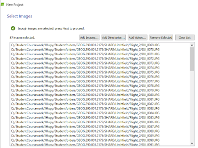
First the user simply adds the images they wish to be processed.
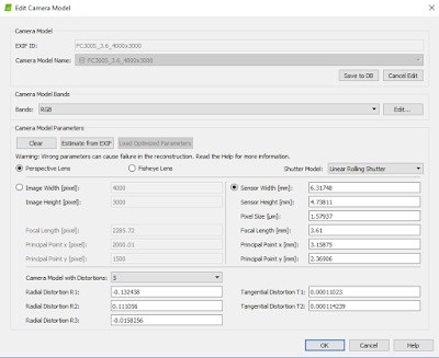
Once chosen, the user reviews the image properties window and makes any necessary adjustments.
In this case, I made an adjustment to the "Shutter Model" to a Linear Rolling Shutter setting before moving forward.
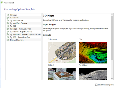
Next, I chose from multiple processing options templates. For this project, 3D Map was chosen.
As a best practice, I chose to only have Pix4D conduct initial processing. All of the processing steps take time. Initial processing generates a quality report that can give the user confidence in the continuing of processing, and avoid losing time processing the remaining steps if the initial processing didn't produce satisfactory results. If the quality report shows that results are satisfactory, the user can then process the remaining data.
Pix4D also allows users to make animations of what's been processed.
Part 3: Maps
The above map is a DSM made with ArcMap from the result of processed imagery through Pix4D. The green areas represent the highest points of elevation.
The above map is an orthomosaic made with ArcMap from the result of processed imagery through Pix4D. Questions regarding the DSM or the orthomosaic can be referred to the other and compared to seek answers. I created one each of the second flight as well, shown below.
Conclusion
I've only scratched the surface in regards to Pix4D functionality. I have no experience with using GCPs or oblique imagery with the software. Thus, it is difficult to fully review the product. What I can say however, is that it is a very useful tool and the software is quite robust and user friendly. I'm impressed with how easy it was for me to process the imagery.
While of course it can be used with images that came from most platforms, Pix4D does give a hobbyist UAS pilot an opportunity to create additional, more geospacially relevant data than they would be able to create without it or software like it. Pix4D adds value to the imagery being processed.
Evaluation
2-Very Little Knowledge
2. Following this activity, how would you rate the amount of knowledge you have on the topic
3-I know enough to repeat what I did
3. Did the hands-on approach to this activity add to how much you were able to learn?
4-Agree
What types of learning strategies would you recommend to make the activity even better?
Using GCPs


No comments:
Post a Comment